India’s remote north-east The road to Tawang
September 2, 2013
by A.R. | TAWANG

DRIVE from the Brahmaputra river, in the plains of north-eastern India, and towards the Himalayas to the north, and hefty obstacles lie in your path. The road up to Tawang, a Buddhist monastery-town near the border with China, takes two long days of travel. From the start you traverse a narrow and muddy track, often single-lane and scattered with rocks. Along this way plod army lorries, petrol tankers, jeeps crammed with passengers. Teams of labourers toil by the thousand along the length of the road. Some chip at stones, others lug rocks aside from the slow-moving traffic.
In time—supposedly another five years—this broken, narrow and vulnerable road will be upgraded to become a “national highway”. But even tarred and smooth, it will offer hazards aplenty. Heavy fog rolls in as the road climbs higher: shortly after a sign gives warning that you are entering a fog zone, the mist closes in and rain begins to patter. With visibility at just a few metres, and with the sound of a huge river rushing in the steep valley below, progress is reduced to a crawl.
There are excuses for the poor condition of the road. A century ago this territory—a stretch of remote land parallel to Bhutan and stretching up to the borders of Tibet—was hardly considered a part of India. The British, before a treaty in 1914 in Shimla, had broadly decided to leave the hill tribes of land now called Arunachal Pradesh to themselves. Tawang, and its surroundings, were administered only loosely, by Buddhist monks from Tibet who levied taxes but did not bring modern government, let alone build infrastructure such as decent roads.
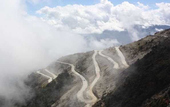
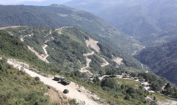
The terrain, too, is hard going. The farther up the road you move, the more unstable the land becomes. Rockslides and landslips are common. Waterfalls thunder from the valley sides. When the rains are strong, these carve new cuts and ravines into the hillside. Much of the valley at lower altitudes is thickly jungled, but higher up trees have been stripped away, encouraging erosion. Heavy monsoon rains bring annual havoc. So steep are the valley edges that the road has to wind back and forth on itself, coiled snakelike up the sides of the mountain.

But there are rewards, too. The end of the first day of driving, past military camps and roadside villages, brings you to Bomdila, a monastery-town on a hillside. Next morning the evidence of Tibetan heritage is already clear: at the monastery, pristine in the morning sunshine, gardeners snip at grass with tiny shears and monks spin at prayer wheels. Soldiers from a nearby military camp walk to a dairy, clanking small, tin churns in their hands.
From here on there is also evidence of the valley’s most turbulent recent history: the invasion of 1962 by China’s army, which cascaded down from the Tibetan plateau high above. The war, 50 years ago, was the result in the short-term of Indian assertiveness, especially in the face of Chinese expansion farther to the west, in Kashmir. The mutual border was (and is) a disputed line drawn by colonial authorities with a thick nib, known as the McMahon line, after the Indian foreign secretary of 1914. China refused to recognise India’s sovereignty over the territory it drew in. Rather than assuage its northern neighbour, however, India chose to push soldiers—and frontier posts—farther and farther forward, even north of the McMahon border.
Yet the longer-term causes of the fighting were messier. China, in the 1950s, had quashed an uprising by Tibetans north of the border. It had also stolen into territory in Jammu and Kashmir state, which India’s considered to be its own land. In 1959 the Dalai Lama, Tibetans’ spiritual leader, fled into India, taking refuge at the monastery in Tawang. He was greeted warmly by India’s politicians and public. Many thousands of other Tibetans followed, forming a government in exile. Arguably the conflict of 1962 was in part a belated, vindictive, reaction by Mao to punish his neighbour for granting asylum to an internal opponent.
Signs of the war are mostly gone. But memorials exist, mostly Buddhist-inspired in their design. They bear plaques with lost lists of names of Indian soldiers (many of the fallen were Punjabi Sikhs, so long lines of “Singh” are carved into black marble) dot the roadside. At the locations of particularly fierce battles—which the Indians, without obvious exceptions, lost—the memorials include accounts of fierce rearguard fighting, in which heroic soldiers gave their lives so others could escape.
By the highest point of the journey, at Se-La pass, the wind is chilly and the air is thin. At 4,700 metres soldiers, road labourers, drivers and tourists alike feel the reduced oxygen. A Chinese-looking archway welcomes travellers to Tawang district, and from here on are views of snow-capped peaks and the Himalayas proper.
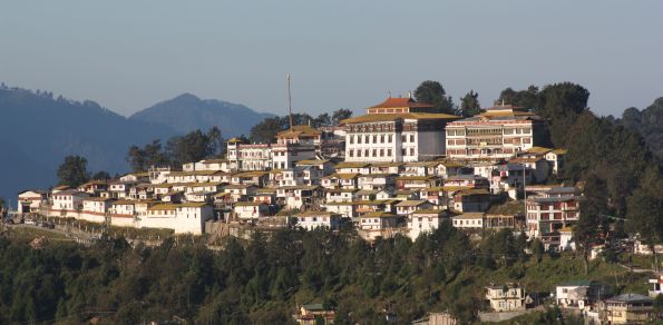
Tawang itself is breathtaking. Its white-walled monastery is strewn with colourful flags and banners. Autumn flowers, some wild, many in pots on houses, decorate the roadside. The people here have the look—high cheekbones, jet-black hair, round faces—of Tibetans, the more so as many are dressed in traditional red and purple clothes, some with yak-wool hats, as they gather to hear a visiting Buddhist leader at the monastery.
Yet it is impossible to forget the military presence. Helicopters lumber overhead with steady regularity—some moving to patrol the border with China, others delivering rations and materiel to forward bases, yet others bringing higher-ranking officers and dignitaries to work. Taking a morning walk I am accosted by a friendly man wearing the unmistakable uniform of a senior policeman the world over: an ill-fitting shiny suit and sunglasses. He quizzes me about my permit—all foreigners need a special pass to enter Arunachal Pradesh—and demands to know if I have yet registered at the local station.

For all that, Tawang is peopled by open, friendly and welcoming residents. By turns the elder ones tell stories of the war of 1962, of the sudden invasion, the panic among Indian forces, the burning of bridges and houses by the retreating army, the relative good behaviour of the invaders. Many interviews, conducted at the monastery, are done to the chime of spinning prayer wheels and the steady murmur of prayers being uttered.
That the border with China is no more firmly settled today than it was in 1962, or 1914, seems to worry only a few in Tawang. From the perspective of local people, the Indian army today looks far better equipped—far mightier—than ever before. Half a century ago the Assam Rifles and other frontier forces carried weapons dating from the first world war, and were dressed in thin cotton shirts suitable for the plains below, not the early winter of the Himalayas. They were easily swept aside by better-prepared Chinese rivals.
Today the army is growing fast. One China expert in Delhi describes half a million soldiers (both Chinese and Indian) camped along the sides of the McMahon line. India is raising four new divisions, some 70,000 additional soldiers in all, to be deployed in Arunachal Pradesh. India’s much expanded economy is providing huge resources for weapons, recruitment, and soldiers’ salaries, to fund its heavy army presence here.
Yet few have much conception of what lies over the border. On the Chinese side, in Tibet proper, the terrain is easier for a rival army. And being more skilled at building infrastructure, the Chinese now have both road and rail to supply their forces on the frontier. For now, nobody imagines that there could be a replay of the war of 1962 in Tawang. But if tensions were to flare again, it is a fair bet that, despite Indian gains in recent years, the forces from the north would be the better-equipped and prepared.
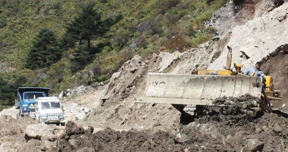
The drive back down from Tawang is no easier. It requires another two days, complete with delays as a bulldozer is dug out from a landslide. We wait too for an explosives expert to dynamite a huge, fallen rock. The route down is entertaining in its own way, punctuated with interviews of elderly politicians and monks, and another night at a monastery’s guesthouse. But the warmth of the Indian plains below is welcome.
3 Comments on “India’s remote north-east The road to Tawang” Post your comment
Featured Insights
- Gurugram: Hero Honda chowk to not choke anymore as Delhi-Jaipur flyover set to open soon
- Future of extensive Smart City projects uncertain
- Financiers express interest for Mumbai-Nagpur super expressway
- Indian start-ups to double by 2020: Nasscom
- SBI inks pact with IIT-Kharagpur for fintech innovation
- Supreme Court refuses to stay Allahabad HC order of making DND fly-way toll-free
- An analysis by CRISIL on the pace of road construction
- Mumbai University gives way for better connectivity at BKC
- Debit card scare: A lesson for banks and their customers
- What is a Smart City ?
The ITW Team
 Sachin Bhatia Chief Editor |


Leisure
E-Z Pass Only

Improved Car Seat Belt 40% Less Accidents

NHAI's First ETC(Electronic Toll Collection) PLAZA
- ETC based on Microwave Technology(CEN 278) implemented at Delhi - Gurgaon Super Connectivity
Technology by: -Kapsch Metro JV.
News Categories
- NHAI (332)
- Highway (233)
- BOT (231)
- Projects (207)
- Default (204)
- Road (182)
- About (175)
- Infrastructure (160)
- Tolling (108)
- Investment and Finance (102)
- Expressway (98)
- Construction (90)
- Smart City (87)
- NHDP (77)
- ITS (65)
- International (55)
- Delhi (53)
- Safety (53)
- Toll Plaza (51)
- Toll Management System (50)
I wanna tel u something about twang district , in our place all the Indian army are corruption n they are very good in black marketing .ex- 1. Selling oil, t all the food item
You’ve got one of the better websites
Thanks really useful. Will certainly share site with my good friends